FAQ
Who?
Who is it, flying in that damned circle?
The most useful piece of information you’ll need to answer this question is an aircraft’s tail number, or registration. It will look like “N1234” or “G-PIXL” or maybe “64-13189”, and it should be included in the bot’s post, or visible on the ADS-B Exchange map. If the bot says “registration unknown” or ADS-B Exchange says it’s a TIS-B contact, then you’re in for a challenge that’s beyond the scope of this FAQ (but maybe someday someone will write a guide or make a video showing how to identify TIS-B targets).
If you’re lucky, the registration will have a suffix that tells you what type of agency is flying it. For example, N665PD is a Los Angeles Police Department helicopter, N306FD is Los Angeles Fire Department, and N702WP is registered to the Los Angeles Dept. of Water and Power. This isn’t a sure thing, it’s just a somewhat common practice in the United States. Sometimes *PD registrations are not police.
If the registration looks like “64-13189” then it’s a U.S. military aircraft.
If it isn’t immediately obvious from the tail number who’s flying it, you can try googling it. You will probably find a web page that tells you who owns it, and sometimes you’ll get lucky and there will even be photos of the aircraft and it will say “DALLAS POLICE” or “ABC 7” on it. If it’s registered in the U.S. and has an N-number like N1234, you can use the FAA’s online N-number lookup.
If it’s police or fire, it will probably be registered to the city, county or state.
News stations often contract their aircraft through other companies, so you probably won’t see one registered to “ABC NEWS 7”. Helinet, Tiny Bubbles Aviation, and Air Sansone are three companies that specialize in providing helicopters to news stations and often show up in registration records.
Often ownership is obscured through shell LLCs and trustees. Again, looking for images of the particular aircraft may help.
Why?
The most common reply the Advisory Circular bots get from people on twitter is literally one word: “Why?” Why is that helicopter circling my house, keeping me awake? Why is that plane flying in circles over my neighborhood?
The quick and easy answer is to check the Citizen app. Citizen is a “location-based safety alerts” mobile app, and if it’s a police, fire, or news helicopter, and if you’re in an area covered by Citizen there’s a good chance you can use it to find out what’s going on near you. Note that Citizen provides information based on unverified radio traffic, so it might be true that the police helicopter is orbiting because someone called and reported a person with a gun, but in reality there is no person with a gun. (Citizen-the-app is one of the best ways to find this sort of information, but Citizen-the-company is terrible, for several reasons. One of those reasons is that they encourage vigilantism, targeting and doxxing innocent people on thin evidence as a way of, of course, increasing engagement metrics.)
If you can’t get an answer via Citizen, then the next step is to know who is flying the aircraft. Knowing the who usually gives you a good start on the why. Refer to the Who? section above.
That’s not a circle?
There’s always* a circle! You probably just need to click on the link to the ADS-B Exchange map and zoom out to see the circle.
Why wasn’t the circle in the image that the bot tweeted? There are a few possible reasons.
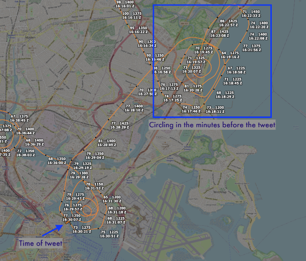
Most commonly, an aircraft may make several circles but it’s not quite enough to trigger the bot. Then the aircraft flies a little ways away, makes a turn, and it’s that turn that finally triggers the bot to post. If the critical turn is far enough away, the majority of the circling won’t be seen in the image the bot posts. Again, if you click on the ADS-B Exchange link and zoom out, you’ll see the circles.
Another reason is that the circle might just be too big. Currently the bots are tuned for the typical circles that fire department, police and news aircraft fly. But when it’s a fast plane flying large circles, the bot may post an image in which the circle isn’t obvious. For example, this is an image that @SkyCirclesR2508 posted of a KC-135R tanker aircraft:
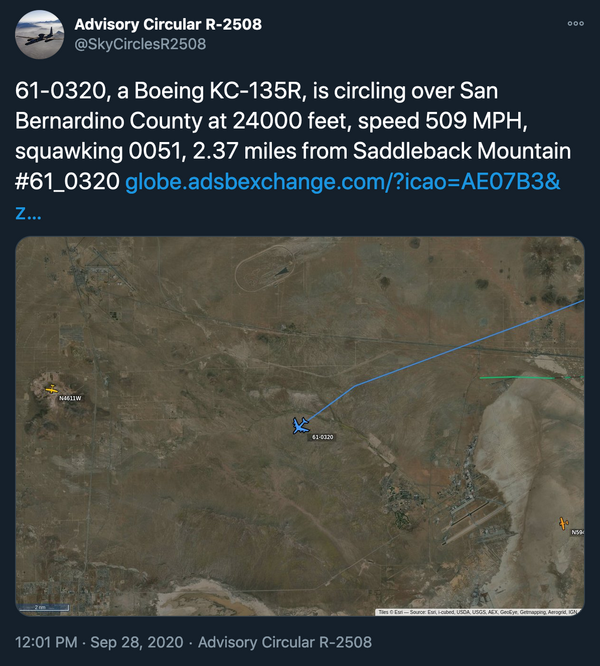
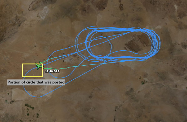
If you click the link and zoom out, this is what you would see:
That’s not a circle.
The bots have a secret: They’re not looking for circles.
The bots are looking for a net change in heading with a magnitude of at least 4 × 360 degrees = 1440 degrees.
That means they would be triggered by any of the following:
- 4 360-degree clockwise turns.
- 4 360-degree counter-clockwise turns
- 2 full clockwise circles, 1 full counter-clockwise circle, 3 more clockwise circles.
- A random squiggle that happens to have a net heading change of 1440 degrees or more.
The bots won’t be triggered by a serpentine or boustrophedonic path where the aircraft keeps alternating its turn direction, because the net heading change will be zero.
Is that a drone?
It’s never a drone. (Until it is.)
In the U.S., there are large drones flying somewhere most days, but it’s very rare for them to fly over large metro areas. It’s only happened a few times, and caused a pretty big ruckus.
A track that looks like a perfect circle isn’t an indication of a drone. Human pilots (and autopilots) can fly very precise circles.
If the bot posts that an aircraft has “unknown registration” or it has a strange ICAO number that doesn’t mean it’s a drone either. It may not be in the registration database the bots use, or it’s a TIS-B contact.
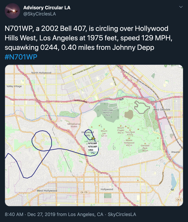
Do the bots track Johnny Depp?
…and what is “Shed”?
The bots try to put circles into context by referencing a nearby landmark. They use OpenStreetMap (OSM) as their landmark database, which is a crowdsourced collection of geographic information that anyone can edit, similar to Wikipedia. So you never really known what you’re going to see for a landmark.
Someone added Johnny Depp’s house to the OpenStreetMap database. It was eventually removed because it violated his privacy, but in the meantime I happened to download a snapshot of the database that included it. Shed is… well, it’s just a shed that someone added that happened to be the closest thing to the centroid of that Cessna’s path. You can check out its detail page on OSM for more information if you must.
At 0 feet altitude? -75 feet?!
Sometimes the bot will tweet that an aircraft is at a strange altitude. 0 feet is common, but negative altitudes happen too.
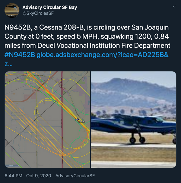
One reason the bots might report an altitude of 0 is that the aircraft is at 0 feet altitude. In the image above, the aircraft is on the ground. Almost all of the circling is up in the air, but at the moment the bot decided to post the aircraft happened to be on the ground. Clearly everything is working as designed and all data is clean and correct.
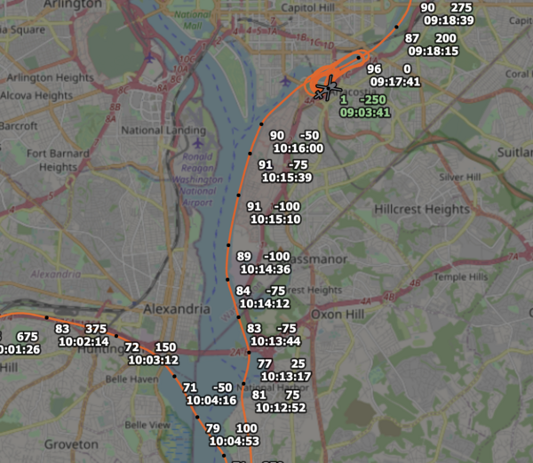
Altitude is actually pretty complicated, and even if the aircraft is reporting its best estimate of its own altitude, it can be wrong. Often altitude is reported based on the barometric pressure. If the altimeter is set to the wrong pressure, the altitude will seem odd. That’s probably what happened in the image above, where as a helicopter descended, it started reporting a negative altitude (the number at the top right of each cluster) while still some distance from the airport. By the time it landed, it appears to have been reporting that it was at -250 feet. There’s no easy way to know what the above-ground altitude is (unless it’s on the ground; ADS-B has a boolean flag that is supposed to indicate when an aircraft is on the ground, so you don’t have to try to guess based on altitude).
Ultimately when aircraft report their altitude it’s all kind of a fiction anyway. From the book Skyfaring, by Mark Vanhoenacker:
Even more curious is that aeroplanes following an altitude referenced to the standard atmosphere collectively and continuously adjust their measure of wrongness—gently climbing or descending as the true pressure changes around them with time, and as they move across the world into different realms of weather. It was a memorable moment of my training when I realised that a plane flying at 35,000 feet is unlikely to be at the same altitude as another plane, elsewhere in the world, whose altimeters also show it to be 35,000 feet; or that if a plane could somehow hover in one place, precisely maintaining its standard idea of 35,000 feet, it would in fact slowly rise and descend with the weather.
There is also the common scenario where the aircraft isn’t broadcasting its altitude. The ADSBX network is estimating the altitude via multilateration, and the height above the ground in particular is sensitive to multilateration errors. In these cases, the data is not clean or correct, but it’s the only data the bot has, so it dutifully tweets it.